Ravi River Corridor · RUDA Zone
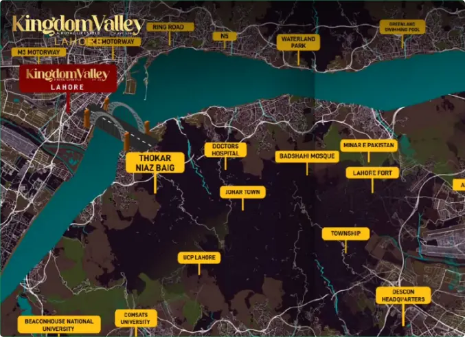
The NOC-approved 600-acre Phase 1 sits in Mauza Koro Tana, Bola Garhi & Katar Band along the Ravi River. But published travel times to the airport range from 15 minutes to 59 minutes depending on the source. Here’s the map, the distances, and how to verify exactly where your plot sits before you book.
Kingdom Valley Lahore‘s RUDA-approved Phase 1 occupies 600 acres along the Ravi River, with its NOC reference (Ruda/D&BC/PPP-01/HS-0086/01, dated 5 October 2023) covering land in the Mauza Koro Tana, Bola Garhi, and Katar Band area. The project’s marketing materials describe two different access narratives for this site: one centered on the Lahore Ring Road’s Thokar Niaz Baig interchange and the M2 Lahore-Sialkot Motorway (roughly 15 minutes away), and another centered on the M-3 Lahore–Abdul Hakeem Motorway and Lahore–Jaranwala Road, with travel times to central Lahore landmarks running 20 to 60 minutes. Before you plan around either narrative, this page breaks down what’s confirmed, what’s disputed, and how to verify the location yourself before booking.
Two location descriptions, one NOC
The official NOC defines one area. Marketing materials describe another. Here’s both, side by side, so you can see exactly where the discrepancy lies.
Flagged
Location discrepancy: the RUDA NOC (Ref. Ruda/D&BC/PPP-01/HS-0086/01, dated 5 Oct 2023) covers Mauza Koro Tana, Bola Garhi & Katar Band. Separate marketing sources describe Kingdom Valley Lahore‘s land as Triddewala, Dhamkey, Mirpur, Saada Wali, Burj Attari & Sangraa — near the M-3 Motorway, a different area along the same river. Request your plot’s exact coordinates before booking to confirm which area applies.
The numbers don't agree — here's where
Rows highlighted in terracotta show figures that differ significantly between sources for what’s described as the same or a similar destination.
Destination
Narrative A (Ring Road)
Narrative B (M-3 / Jaranwala)
Allama Iqbal Int’l Airport
~15 minutes
59 minutes
Thokar Niaz Baig (Ring Road)
~15 minutes
30 minutes
Park View City Lahore
Adjacent
12–16 minutes
Sharaqpur City
~15 minutes
20 minutes
Sharaqpur Toll Plaza (M-3)
~12 km
25 minutes
Central Lahore
–
38 minutes
Babu Sabu Interchange
–
5–34 minutes*
RUDA Corridor Context
Regardless of which narrative applies to your plot, the project sits within RUDA’s broader Ravi Riverfront Urban Development corridor — a designation shared with many neighboring societies.
RUDA’s master framework for this corridor designates future zones referred to as Medical City, Government City, Knowledge City, Smart City, Sports City, Tourism & Development City, and Commercial City — civic planning areas spanning the wider Ravi corridor, not amenities unique to any one private housing scheme. Their timelines depend on RUDA’s own progress, not any individual developer’s.
What This Means For You
“Near RUDA’s planned cities” is a claim shared by every society in this belt — it’s not a differentiator unique to Kingdom Valley Lahore. The location-specific question that actually matters is which mouza your plot sits in, and how that translates to real drive times — not which future civic zones the wider corridor is expected to contain.
Nearby Developments
Park View City Lahore is the most consistently cited neighbour — useful as a real-world comparison point for on-ground progress and travel times.
Directly adjacent under Narrative A, or 12–16 minutes away under Narrative B. The most established neighbour — a useful sanity check for travel-time claims.
Part of the same wave of Ravi-corridor launches, contributing to overall area development momentum.
A smart-city-positioned development in the same belt, often cited alongside RUDA’s broader master plan.
Established projects in the vicinity contributing to population growth and commercial activity in the corridor.
Additional recent entrants in the same growth corridor — part of the broader competitive supply for resale buyers.
Further societies in the cluster — their combined presence reduces development risk for the area as a whole, but increases resale competition for any single project.
Verification Steps
Three steps — doable entirely remotely, even for overseas buyers — before you transfer any funds.
1
Ask the sales office for a shareable Google Maps pin for the specific block and plot number you’re being offered — not a general project location.
2
Compare those coordinates to the 600-acre area defined in Ruda/D&BC/PPP-01/HS-0086/01 for Mauza Koro Tana, Bola Garhi & Katar Band, checking RUDA’s own listings.
3
Use current Google Maps routing from those coordinates to the destinations that matter to you — don’t rely on marketing-page figures, which may be outdated or describe a different reference point.
Frequently Asked Questions
Click any question to expand. If yours isn’t answered here, contact our team directly.
The RUDA-approved Phase 1 NOC covers 600 acres in Mauza Koro Tana, Bola Garhi, and Katar Band along the Ravi River, adjacent to Park View City Lahore. Separate marketing sources describe the project’s land using different village names — Triddewala, Dhamkey, Mirpur, Saada Wali, Burj Attari, and Sangraa — near the M-3 Motorway. Request exact GPS coordinates for your specific plot’s block before booking to resolve this.
One set of figures cites roughly 15 minutes to the Ring Road’s Thokar Niaz Baig interchange via the M2 Motorway, while another set cites around 30 minutes for what’s described as the same reference point. The discrepancy likely reflects different starting points within the project’s land bank — confirm the distance from your specific block directly.
Marketing figures range from roughly 15 minutes via Ring Road and the M2 interchange to 59 minutes from a location near the M-3 Motorway — a nearly four-fold difference. This is the clearest evidence that different sources describe different reference points, and it’s the single most important figure to verify for your specific plot if airport access matters.
Yes — Park View City Lahore is the most consistently cited neighbouring development, described either as directly adjacent to the NOC-referenced Phase 1 site or as being 12 to 16 minutes away under alternative descriptions. Its own published travel times can serve as a useful comparison point given the proximity.
At least one source describes a “Phase 2” location near the M-2 Lahore–Islamabad Motorway’s Ravi Toll Plaza, roughly 20 km from the Phase 1 site, with its own travel-time figures to landmarks like Jinnah Hospital and Babu Sabu Interchange. This area isn’t referenced in the Phase 1 NOC, so confirm its approval status separately if offered Phase 2 plots.
Request a shareable Google Maps pin for your specific block and plot number directly from the sales office, rather than searching generically. Given the discrepancies between published location descriptions, a generic search is likely to return one of several possible reference points rather than your plot’s exact location.
Request a shareable Google Maps pin for your specific block and plot number directly from the sales office, rather than searching generically. Given the discrepancies between published location descriptions, a generic search is likely to return one of several possible reference points rather than your plot’s exact location.
Location determines both daily-use convenience and the competitive landscape at resale — Kingdom Valley Lahore sits within a corridor including Park View City Lahore, New Metro City Lahore, Ravi Smart City, and others, all competing for the same buyers. A plot with strong Ring Road access is a different product, at a different point in its appreciation curve, than one with a near-hour drive to central Lahore.
The broader RUDA corridor thesis — government infrastructure investment driving land appreciation along the Ravi River — applies here as it does to neighbouring societies, following a pattern similar to Ring Road’s effect on Lahore’s periphery historically. Whether Kingdom Valley Lahore’s specific plots are well-positioned depends on resolving exactly which location your plot occupies, making plot-specific verification more important here than for projects with a single, unambiguous site.
Speak to the sales office
Given the discrepancies above, this is the single most valuable thing you can ask for — and a legitimate sales office should provide it without hesitation.